Difference between revisions of "Map Finder"
The Wiki of Unify contains information on clients and devices, communications systems and unified communications. - Unify GmbH & Co. KG is a Trademark Licensee of Siemens AG.
(→Operation) |
|||
| Line 1: | Line 1: | ||
| − | |||
Until recent times, map finding services were limited to computers, mobiles etc., but now the Map Finder application enables the users to view desired maps/directions on the [[optiPoint_application_module|APM]] of IPPhone. | Until recent times, map finding services were limited to computers, mobiles etc., but now the Map Finder application enables the users to view desired maps/directions on the [[optiPoint_application_module|APM]] of IPPhone. | ||
{{Info|Most importantly, this application uses IPPhone instead of computer to print out the map of the desired location.}} | {{Info|Most importantly, this application uses IPPhone instead of computer to print out the map of the desired location.}} | ||
Latest revision as of 07:25, 24 October 2008
Until recent times, map finding services were limited to computers, mobiles etc., but now the Map Finder application enables the users to view desired maps/directions on the APM of IPPhone.
| Most importantly, this application uses IPPhone instead of computer to print out the map of the desired location. |
Operation
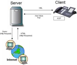
Operational Overview:
- A Map Finder application on the phone interacts with the server using XML. The server provides XML to the phone which the application renders into a screen for the user to interact with. The user’s interaction with the phone results in key-value pairs being passed back to the server for processing.
- The server in turn sends a query (HTTP Request) to web-based services and obtains HTML data (Http Response).
- The server then creates an XML page with the data obtained from web-based services and sends it back to the IP Phone.
Key Features
- View Map
User can view map of any desired location by simply entering the location name or the post code.
- View Directions
User can view text based directions of route between two specified post codes i.e. post code of starting location and post code of destination.
- Zoom Map
User can specify the part of the image he wishes to zoom into and the image will then be enlarged to fit the APM screen.
- Print Map
User can print the desired map using the default printer connected to the main server of the application. Thus enabling the user of printing a friendly version of the map to take on the road.


